Sunday, 29 November 2015

The childhoods of my grandparents

This post is about the parents of my father. They were both born in 1939, and grew up in the 1940s and 1950s in the American Midwest. The purpose of this post is to explain what life was like for children and adults back then.

There were no video games at that time, and TV was very new back then. My grandmother remembers one time when she was in Brownie Scouts(the young Girl Scouts), and her troop went to one girl's house because she was the only one in the troop that had a TV. When they turned it on, the screen just showed a test pattern, like the one on the right. The test pattern would be on in between programs(The old televisions only had about three channels, and not very many shows). The troop waited for a while, but no shows came on, so they left.
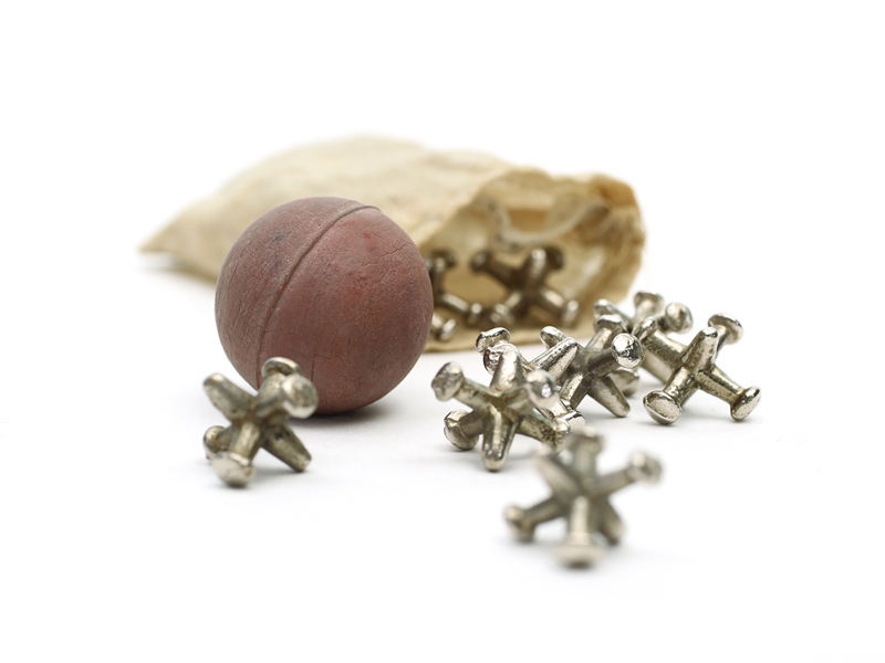
As you can see, TV wasn't all that great back then, so children entertained themselves by playing "make-believe" games like House, and other games like hide-and-seek. Plastic had not been invented yet, so toys were made of rubber, metal, and wood, like the Jacks set on the left. My grandparents also played board games and read books.


Computers were another change from back then. For example, people had to go to the library to look up things. There were also no good word processors, so they had to write something down first and then type it up on a typewriter. When you press a key on a typewriter, it would push some levers and a metal arm with a letter raised from it would go up and press on a ribbon. The ink on the other side of the ribbon then gets pressed on to a sheet of paper. The big difference in between writing with a typewriter and writing with a word processor is that if you wanted to correct a mistake or add another paragraph in a place where you had already written, you would have a lot of trouble going back and changing it!

Making copies of written things was also hard. It was done with carbon paper. Carbon paper is paper with loose ink or another pigment on one side, so if something, like the type on a typewriter, was pressed on the coloured side, then the black side would transfer its pigment to a sheet of paper below the carbon paper. In this way, it was possible to make copies while typing. For a short time before my grandmother went to college, she got a job as a clerk-typist at a clinic. Every day, she got a list of doctors that were out that day, and her job was to type up that list and, using eight sheets of carbon paper, make eight copies of the list to send to different departments.

                 
For art there were crayons and pencils, but no magic markers. The only pens were fountain pens. There were jars of ink and to fill up the pen you had to put its tip into the jar, and then pull a little lever to suck up the ink. In the 1950s, they had cartridges of ink that you could just put into the pen. One problem with fountain pens was that they work using a little channel that the ink runs through, so they would often leak and make blotches of ink on the paper.
The amount of polio cases in children and adults in the United States.

Another change that happened since the 1940s was polio vaccine. Polio was a very scary disease that mostly affected children. The poliovirus is a very simple virus that infects the gastrointestinal tract and usually causes minor symptoms such as fever and sore throat, but sometimes breaks into the central nervous system and causes paralysis, respiratory arrest and death. Parents, being scared of the disease, would not let their children go in to public places like swimming pools and movie theatres. Because poliovirus can only infect humans and cannot reproduce in nature, introduction of the polio vaccine has eliminated polio from most of the countries in the world and dropped the number of cases from an estimated 350,000 in 1988 to 52 in November 2015. This has caused a huge difference to the world, because all the worry that this disease has caused in countries like the United States is gone now.

Another thing that people were afraid about was World War II. When it started, the United States, facing unemployment and economic disaster due to the Great Depression, was reluctant to join, and only sent money and weapons to the Allies instead of soldiers. At December 7, 1941, the Japanese bombed a naval base at Pearl Harbour, Hawaii. The United States government finally spent more money to start up the economy and hire more soldiers to join the War, ending the Great Depression. You have probably heard of famous battles like the ones in Okinawa and Iwo Jima in the Pacific, and Omaha beach in Europe at D-Day. Other famous times included VE day(Victory in Europe), when Germany surrendered, and VP day(Victory in the Pacific), which was the surrender of Japan. How did all of that affect peoples' lives during the 1940s? For one thing, poor families lost fathers and older brothers, when they went to become soldiers in the War to support their families. Other people followed the news in theatres or with the newspaper. In American cities, there were air raid drills, when people covered up all of the windows with blankets or turned all the lights off, so that no light could be seen from outside, or above. This was probably because they were scared that enemy bombers could see the light and bomb the city, like they did in World War I.

The basic crowd opinion of everybody in the U.S. was that people on their side were "the good guys" and that the opposing countries were "the bad guys"(When they were young, my grandparents played games where they pretended to be heroic soldiers who were going around, killing the Japanese). This opinion has led to war many times, war strengthens that opinion, which leads to more wars, and so on. As population grows, resources decrease, and gases in the atmosphere cause climate change, the countries must learn to co-operate, and deal with these problems.

Thursday, 19 November 2015

War

You must all know about the crisis going on in Syria and Iraq right now. Millions of refugees are fleeing Syria. The powers of the world are getting involved in it, and there is no end of war in sight.

Why doesn't anybody do anything about it? How did Syria get into this mess in the first place???

I'll explain. It started many years ago, at the end of the Second World War.

At the end of the war, everybody was settling down into new boundaries, but the Middle East had not been defined yet. So the more powerful nations met together to discuss countries in the Middle East. They eventually came up with a plan to create several new countries such as Syria and Israel. In these tiny countries, ethnic communities were scattered, and each group wanted to rule. In Syria, the democratic rule set down by the founders of the country toppled and was replaced by Alawite rule. Alawites are an ethnic minority in Syria. The dictator himself was Hafez Assad, who ruled until he died in 2000.

The new dictator, Bashar Assad, promised a democracy after several peaceful protests. The protests were triggered by other countries toppling their dictators in the Arab spring. However, Assad remained the dictator, while imposing restrictions on the Sunni, the ethnic majority in Syria. He soon became very unpopular. Starting around 2011, protests became riots. Eventually, the people armed themselves and braced for a civil war. Everything began with little groups, mostly in the West of Syria, fighting back. Some of the groups began to join together, and some of these larger groups were strong enough capture entire pockets of land from the government.

Around August, the forces joined together, took over vast areas in the west and north of Syria, and called themselves the rebels. As the government of Syria began to weaken, a new group entered the battle, the Kurds. They came from the north of Syria, and have been creeping slowly southward ever since. Before the Kurds entered the war, the Gulf states had been supporting the rebels, and Russia had been against them. The United States had not actively entered the war, but they favored the rebels. Now that a third group had been introduced, everything changed. The United States could not decide who to support. Russia and other countries had trouble deciding, for various reasons, to support the war.

Around this time, millions of refugees began spilling out of Syria. The war had begun in its earnest. In 2014, yet another group had joined the war; the extremist group known now as the Islamic State of Iraq and Syria, or ISIS. The group, in an aim to create a new country, expanded into Iraq and Syria, mass killing people and galvanizing the world against them. They took over a lot of land from the rebels and the Kurds, and became the richest terrorist group in the world. Around January 2015, they were turned around in Iraq. To compensate for lost territory, they expanded into Syria and now have taken over about 55% of the country, but they are slowing down there too. Some are worried that this may cause the Islamic State forces to take the battle to the international scheme, like what happened in France. ISIS are attempting to draw the world to them because they want an apocalyptic battle to happen in Syria. They believe they will go to heaven by going down fighting.

There is no knowing when this will end or how. However, whoever wins power over Syria will inherit a country in ruins, with the responsibility of cleaning up an entire desert.

Despite the violence going on, most of the civilized world is not concerned with the war, but with the refugees coming from it. A quarter of Syria's population has already fled Syria, and there are more to come. Some are afraid of this swarm of refugees, but there is not much reason to be. They are capable of integrating themselves into a new community, and may help the society of Western countries in years to come.

Tuesday, 10 November 2015

Movements

 A hundred thousand years back, mankind had just evolved in the Great Rift Valley of Africa. These people had fires, arrows, spears, and an advanced brain. They had power over many tools and inventions, but all of these inventions were created millions of years before. No human development seemed to be happening.

Suddenly, a drought appeared, and all sources of water in the valley dried up. And the newly evolved species began to move away, first to the south and west. When the drought lifted, people kept moving away, for they had found more fertile valleys to live in. Around 80,000 years ago, people crossed the then very wide land bridge between Africa and Asia. They poured out into a series of muddy valleys, and kept on going. Somewhere in this land, which is now the Middle East, the people split into two different types; generally white people and black people. The black people filled up the rest of Africa and went on to China, India, Australia and Melanesia.

Meanwhile, a group of lighter-skinned people made their appearance in Europe, covering the continent by 40,000 years ago. Some of these lighter-skinned people resumed their colonization, and streamed into northern China through Siberia. They or the other darker-skinned group eventually colonized Polynesia around 5,000 years ago. Around China the genome changed, and gave rise to Native Americans. This stream of people traveled across the land bridge into the Americas and arrived at Cape Horn 10,000 years ago.

Homo Sapiens had just conquered the world. While they were doing so, to fit in with whatever place they were in, they had made many new inventions; the raft in Polynesia, the boomerang in Australia, the bullroarer in Africa, farming in the Middle East. The entire species had developed greatly, just because they had to move out.

That was when people settled down -- well, not really. People have been on the move forever since, whether for family, or for money, or as refugees from drought, war, or famine. Most people do not live in the same house their great grandfather was born in. Humans are always on the move.

Migrations of people still help shape the world today. If nobody ever moved to a different place, all 7 billion people in the world today would have lived in one concentrated spot in the Great Rift Valley of Africa.


Friday, 6 November 2015

The Great Barrier

Some continents may be low and flat, but not one continent exists in which there are no mountains.

Mountains are the pulsing heart of regions with infrequent rain or little snow, because snow collects on high mountains in the winter to melt in the spring, creating a fluctuation of growth which make the growing season for plants and trees longer. And mountains don't just do that; they create barriers which can steer away heat and trap rain in parts of the world, usually on the eastern side of a mountain range. In this way the American Rockies created the Mississippi River Basin, an area of great growth and richness (although not in the cities) and the Andes created the Amazon Basin. The highlands of western China guards, to a certain extent, Beijing from the wind and dust of the Gobi Desert.

Mountains are one of the most important biomes in the world, and must be protected. In this blog entry, I am going to write particularly about low mountains.

Although low ranges of mountains are not as influential as big ones, they do make a big difference to environments. The natural ecosystems east of the Appalachian Range in the USA, or what's left of them anyway, are very different to the forests of the Range itself, or the plains behind them. The Appalachian Range forests are part of one big plateau, the top being light woodland and dense scrub, the bottom being tall, stately trees with little underbrush. The lands to the West are dry woodland and some grasslands, and the coastal vegetation is mostly open woodland dominated by low trees.

The forests, alpine fields, grasslands and equatorial forests of the Great Divding Range in Australia are completely different from the Appalachians. To the west are dry, hot, dusty grasslands, and to the east are coastal forests and ranges which vary from place to place. However, for the mountains themselves, it really depends on which part of the map you are pointing to. To the northernmost end of the range stand equatorial swamps of great size, spanning the large Cape York Peninsula, and just to the south of that is the Daintree Rainforest, the only rainforest in Australia, which contains some of the oldest species in the world.

To the south of this is a very large in which there are a few scattered hills, but overall the entire place is dry and dusty, like a desert except for periodic floods. Eventually these tablelands are broken by a vast tabletop mountain and a colorful range called the Carnarvon Gorge, which contains several spectacular gorges and slot canyons, pillars and layered tiers of bare rock. Further to the south, is the beginning of a large World Heritage Area, the Gondwana Rainforests. These forests have basically been preserved in time, and a thick layer of fog only the highest mountains can pierce, for 100 million years.

To the South of that is the Blue Mountains, a massive wilderness of narrow gorges, parts of which are so remote entire types of trees have been quite recently found there. Then the Snowy Mountains, the only area in Australia where snow settles. Finally, the mountain range curves to the West and ends with a group of razorback ridges called the Grampians.

An explanation of why the two mountain ranges are so different can be derived from their formation. The Appalacians were formed by a great uplift that began many years ago. This means the mountains were mostly uniform in height in composition. The Great Dividing Range of Australia was formed by a volcanic hotspot like Hawaii. This means that, like piece of paper being moved below a hole puncher, the earth's crust was repeatedly punctured by a magma plume, causing earthquakes, and volcanoes. During each "puncture", the volcanoes varied in size, intensity, and height, explaining why some parts of the Great Dividing Range was only uplifted in some areas whereas others are completely made of basalt or granite. This creates an incredibly varied landscape.

Of course, this does not mean all "uplift" mountain chains are uniform along their length. The Himalayas, for example, certainly aren't. This is because the Himalayas are made of a particular type of rock that only  weathers most in certain situations. The American Rocky Mountains are slowly being stretched apart so that the Southern part of the chain is lower than the northern part.

Wherever they are, however they are formed, however high they are, mountains will always serve as driving forces in the culture and prosperity of peoples around the world. They will always serve as "great barriers".

Saturday, 24 October 2015

The North East

 The Beginning

Last vacation, I went to Tasmania, the southeasternmost state of Australia. Now, almost 6 months later, I travel in Australia's northeasternmost state; Queensland.

In the Tasmania vacation, my prime objective was to climb Cradle Mountain. Traveling in the southeast corner of Queensland, we would spend the longest time in one place: Carnarvon Gorge on the Great Dividing Range, part of Carnarvon National Park, one of Queensland's largest.

We began the trip by driving through the northernmost Brisbane suburbs, which extend up to 50 kilometres from the city itself.

Half an hour later, we were in the Sunshine Coast. The Sunshine Coast is known for its beaches and natural beauty, but we completely surpassed the beaches, driving off of the main highway and driving inland on a narrow, hilly road known as the D'Aguilar Highway. We had filtered views of the Glass House Mountains, isolated volcanic plugs that to me looked very much like grassy teeth, pointed upward toward the sky. And that was it for the Sunshine Coast.


After the road climbed a bank of low hills, we entered the D'Aguilar region. This was an area of wooded hills and dry, hilly country, small towns and no rivers. To the south, the D'Aguilar Range was visible. The range runs for over 90 kilometres from where we were all the way to Mount Coot-tha, which is just 5 kilometres from the Brisbane CBD.

Suddenly, the highway curved north and joined several much smaller roads also bound for the Whitsunday Coast and the coal port of Rockhampton, which sits in an otherwise desolate sweep of coastline nobody would have lived in if it wasn't for the coal mines. Dozens of destructive, open-cut coal mines in the hot, dry plains between the Great Dividing Range and the sea. Our route led away from the coast, but we would still find evidence of the black rock deep under the soil.

Now we were in the main part of the trip. It looked like some giant had pounded the ground hard with a mallet. A really dusty one. There were no landmarks, no mountains or even hills, and the land would look and feel like the Sahara if grass had not evolved to live there. Suddenly, as the sun approached the horizon, I saw a line of hills slowly rise out of the dust. Even the dust disappeared. What replaced it was real earth. A few minutes later and I was there: Cania Gorge.

Cania Gorge

Cania National Park looked like nothing when I first arrived; just two hills with a gap in the middle. However, the gap between the hills is very narrow and lined with cliffs, and there are equally narrow side gorges. The walks lead to lookouts, caves, and waterholes.

The campground at Cania Gorge, which I stayed at for two nights, was next to an empty streambed. Most of the walks began at the campsite itself. I had a good night's sleep in the tent, and the first thing I saw that morning was Big Foot.

Big Foot was almost visible from the campsite, and was only 100 metres from it. It was a massive stain in the rock shaped like a foot. Not very interesting, but it was worth the short stroll.

Under towering cliffs, we continued walking on the valley floor. In a few minutes, the path bent a little and led into a side gorge.

The gorge was narrow and dark, and parts of it were like a slot canyon. The streambed was dry. After an hour of walking, I reached a waterhole, and almost jumped with joy. After walking through some hot, dry landscape, I had reached a deep waterhole, complete with a waterfall and lined with ferns and moss.

The next part of the walk climbed steeply up a slope, passing some large walls of rock. At the top of the slope, scrubby plants dominated. While walking, I decided the entire landscape seemed eerily familiar to me. Then, it hit me. The rocks, the dry ravines, the steep slopes and cliffs, and the scrub reminded me of Brisbane Water National Park, a place almost exactly like this, except much larger. Brisbane Water National Park was a place I hiked in a lot before I moved.

The path, gradually sloping upward, arrived at Giants Chair, a lookout with "giant" views over the surrounding hills. We did not stop for long, and just after reaching Giants Chair, the path descended an almost sheer cliff. Just below the cliff was the campsite. Since it was still barely noon, we embarked upon another hike.

This hike was much shorter than the previous one, and it visited no less than three sandstone caves. The first and best one was called Two Storey Cave. At first it looked like a normal overhang, until I crawled into the deepest recesses of the cave and found the second storey. The entrance to this deeper part of the cave was just wide for me to squeeze through, but it opened up into a massive space I would never have known existed. I mean, it was the size of a small church.

The second cave, Dragon Cave, was only an overhang, but the third cave, Bloodwood Cave was more interesting because it had this strange pillar in the middle.

Blackdown Tablelands

The second day was more boring than the first. For one, it was longer, and two, it was hotter. Instead of visiting the coast, we followed the Capricorn Highway through desert like country inland.

The first big landmark we saw was Blackwater. Aptly named, Blackwater is the coal capital of Australia. Not like we could not have noticed the presence of coal with those hundreds of coal trains coming from Blackwater and going to the coast.

Shortly after Blackwater, I spotted a high, tabletop mountain on the horizon. As we drew closer, I noticed high cliffs present on all sides of the mountain. This was the Blackdown Tablelands. We exited the highway once again, and the car bumped down a gravelly road. The land slowly became more lush.

Suddenly, we were climbing the side of the mountain. We gained altitude so fast, my ears popped three times. Just beyond the top, there was a lookout. We all got out of the car to have a look.

As soon as I stepped out, I felt like I was in a lost world. The vegetation was very different from what I had ever seen. The lookout was great, and I could see for about 100 kilometres, but there were no other hills in sight. This mountain was alone. I learned later that it had been protected because most of the plants were poisonous.

We had lunch, and set camp. Camp was among strange looking boulders that I could not resist climbing. I had little sleep that night, but it was substantial.

We did four short hikes on the next day. One led to a lookout, and it followed a riverbed that looked like an art museum with the colours and weird shapes of rock. The next one simply took me around the unusual, otherworldly landscape, and so did the next one.

I liked the last hike the best. It descended into a gully, to a waterfall so long it vanished before hitting the massive circular pool below. The entire thing was surrounded by 300 degrees of cliffs that dripped with moss. It was overwhelming to see so much water in such a dry area.

Emerald

On the next day, we left the tablelands, and submitted to another day of driving to a canyon known as Carnarvon Gorge. This day was longer than the previous two driving days, but was somehow made bearable by the hills and interesting towns on the way.

Several hours out, we arrived at Emerald, a town famous for its crystal mines. The town was interesting because everything looked like it was plucked out of the 1930's; the houses, local stores and cafes, and even the public buildings such as the library and the school. Even the McDonald's looked old fashioned.

We had lunch in Emerald (We bought it from the only modern looking building in town, the supermarket) and hit the road again. Soon, the horizon was broken by a line of hills. As we drew closer, I noticed colorful sandstone cliffs everywhere in the mountains. We rested in the last town worthy of its name -- Blinman -- before the emptiness that was the Carnarvon Range,  and set off again. Cattle stations now flanked both sides of the road, like usual since we departed from the Sunshine Coast, but just beyond those cattle stations were massive sandstone cliffs, and just beyond those cliffs were national parks, which preserved massive tracts of unbroken wilderness.

Two hundred kilometres out from Blinman was an intersection, the left branch continuing down a wide valley, and the right branch aiming for the mountains. We took the right branch.

Storms could be seen in the valley. The land changed from cleared land to dry bushland. All views of the white cliffs up ahead disappeared with the open land. Not much longer, we drove past what looked like as massive ribbon of steel, twisted, burnt, bent, and broken. It was sitting in a clearing. I learned I was looking at the Rewan Memorial, an airplane crash site.

The sky looked like it was going to fall on top of us at any moment while we arrived at the campsite. The white cliffs of the Carnarvon Gorge were hidden from us by a line of ridges, but the entrance was just 5 kilometres from the campsite, and it was waiting for me.

Carnarvon - The Lower Gorge

On my first day at Carnarvon, I got up early to begin hiking.

It was a short drive to the entrance of the gorge. People never attempted to make a road that leads into the gorge, which surprised me; it usually seems to me that, if people find a chance to shorten their hike by 10 kilometres, they would take it, but I was later very glad this development did not take place. The gorge itself is a place that must be preserved.

Anyway, I could see the cliffs from the trailhead. They were white and 200 metres tall, the gorge roughly two kilometres wide at this point. Out of it flowed a river, which apparently flows all year; something to see in the harsh landscape of central Queensland.

We crossed the river by rockhopping on stepping stones, and after that the path climbed very quickly. We were very close to reaching the cliffs themselves.

The top of the climb was the site of an intersection. Carnarvon Gorge has a very simple walk system. The main path more or less follows the river, and there are side tracks which climb straight up to the cliffs and the park's various attractions. The first side trail, which was here, scaled the cliffs to a lookout at the top called Boolimba Bluff. It was the only trail that climbed out of the gorge.

The trail, staying out of sight of the river, climbed through a hilly area near the cliffs. There were no views, but there were giant cycads everywhere.

After crossing a few dry gullies, I came in sight of the river again, only for a moment. The cliffs came easily into view, and a large side canyon materialized on the left.  Then the river curved away from me, and trail, six kilometres from its starting point, arrived at the second intersection.

The second side trail led a kilometre into the aforementioned side canyon. I did not take this side trip or any other one on the way up because we were planning to climb into the gorge as far as we wanted to go and do the side canyons on the way back. As "far as we wanted to go" happened to be a very long distance, but not close to the top of the gorge.

We walked for two hours into the gorge. The vegetation kept changing, and we experienced six river crossings. The gorge also kept getting narrower, and the gorge walls only got taller. The fifth turnoff was for an Aboriginal art site, but we did not walk any farther. By this time, the gorge was only 500 metres across.

The aboriginal art site, called the Art Gallery, was possibly the largest I have ever seen. It was painted on a massive smooth wall of rock. We soon moved on, down the gorge.

Then there was a turnoff for Wards Canyon. Three hundred steps up the turnoff there was a beautiful waterfall. It was just below the place where there should have been a bigger waterfall, pouring from the cliffs above.

But there was not another waterfall.

The trail climbed to the top of the waterfall, and at the top was a slot canyon; a canyon a hundred times deeper than it was wide. It was so deep, sunlight must never reach the bottom. At the end, there were a cluster of king ferns, the largest fern in the world; ferns six times taller than me.

The next turnoff was the Ampitheatre. The trail was flat until it climbed a ladder to reach a slot canyon even narrower than Wards Canyon. However, this was not the highlight. The canyon led into a massive rock chamber with a hole in the roof. It really was something to see.

The last turnoff was Moss Garden, the side trail I mentioned earlier. Steps climbed among stranger figs to a spring, where water trickled from the rock into a bed of colorful mosses. It was a nice place to have a sandwich in.

That was the end of the first day of Carnarvon. On the second day, I climbed all the way into the neck of the gorge.

Carnarvon - the upper gorge

That evening, we went to a free talk about the gorge and what there is to see there, by a tour guide.

The person giving the talk began by talking about the geology of the area. Apparently there are three layers of stone in the gorge. The first one is mudstone, and it is all of the rock below the white cliffs of the gorge. It does not form cliffs and erodes easily, explaining the flat nature of the bottom of the gorge.

The second layer of white sandstone is what makes the cliffs. The top of the layer rises 200 metres above the river.

There is a third rock layer, too. It apparently rises 800 metres above the river, even though I never even saw it! It is a basalt cap and it preserves the Carnarvon Range from erosion.

The guide also talked about other things, such as the various attractions in the park. He spoke of three parts of the gorge. There is the lower gorge, which contained everything I had seen on that day, and the upper gorge, which was separated from the lower gorge by 5 kilometres of windy canyons. The last area was the gorge mouth, which included Boolimba Bluff, the riverside walks which were centered around a waterhole, and Mickeys Creek, which seemed to be the guide's favorite place in the gorge. It was some kind of slot canyon.

Anyway, I and Dad planned to take the 22 kilometre hike into the inner gorge.

The hike as far as the Art Gallery felt very different the second time I did it. The first area of rolling hills was burnt and dominated  by giant cycads. After the Moss Garden turnoff, everything changed, and we stayed within sight of the river, walking in the grassy woodland. Further than the Ampitheatre, the walk traveled among sheoaks by the riverbed. And past Wards Canyon, we wandered among giant trees in a rainforest.

Then, past the Art Gallery, everything changed. The walk wandered the riverbed, which was very broad. We were about to walk back into the forest, when we lost the trail. I just could not find it. Afterward, we wandered the broad riverbed, knowing the trail would cross it.

I was very glad to lose the trail. At this point, the gorge became higher than it was wide, and the riverbed almost dominated it. Wandering among the massive cliffs in the middle of nowhere, this was nicer than walking on the trail would be.

After a few sketchy creek crossings, I found the trail again. I followed the track through the trees for four kilometres between colorful cliffs, and came to the Cathedral Cave, an Aboriginal art site. It was relaxing to be away from the sun, under an overhang. After a long rest, I came upon Boowinda Gorge. The gorge was narrow, dark, cool, and filled with butterflies. I wandered down it, walking 600 metres along the boulder-filled canyon. This became my favorite place in the gorge.

The end of the track was arrived at very quickly. It was a place where the river bent, and the cliffs bent too, creating a gorge with a 70 degree cliff on one side and a 120 degree cliff on the other. I felt very far from civilization, as the nearest road seemed very, very far away.

It took 3 hours to walk back, but everything I did to get to this isolated place was worth it.

Carnarvon - The Gorge Mouth

We woke up before the sun rose, and packed up for a 3 hour hike to the top of Boolimba Bluff.

The walk involved climbing 2000 steps. It was very hard. However, from the top, I could see everything. I spotted the three layers of the gorge: A limestone ridge below the gorge, the sandstone cliffs we were perched on top of, and the mysterious third layer, a massive step of igneous rock. I thought the gorge was big, but this third layer gave it an entirely new Grand Canyon dimension.

At the end of the hike, we took another walk, to Mickeys Creek. It took a long, boring walk to get to Mickeys Creek, and after that the trail ended.

There are two gorges in Mickeys Creek: Warumbah Creek, and Mickeys Creek. Warrumbah Creek was the most spectacular, but I also wanted to visit Mickeys Creek. I ran ahead while my brothers were resting, and after running on the creekbed for long enough, I got to the gorge entrance. It was dark and inviting, but I knew my brothers were waiting for me, so I rushed back.

Warrumbah Creek was great. It was a slot canyon so narrow I could touch both sides at the same time, and so deep it was half as deep as the gorge. However, it was crowded, and there were deep pools in the bottom, making it harder and harder to go farther. I got rather far before I gave up.

Conclusion

That was my last day at Carnarvon. Next day, we drove to the Bunya Mountains. I did not stay long, but the Bunya Mountains is a rainforest with a few grasslands. On the next day I went home.

I had seen a lot of stuff in central Queensland and Carnarvon Gorge. I will be back!

Friday, 9 October 2015

The iconic nature of Cradle Mountain


We are lucky to have so much natural beauty around us in the age we live in. There are colourful canyons, beautiful waterfalls, and majestic mountains. One of the most interesting of natural attractions is the volcano. Volcanoes, even the extinct or dormant ones, shape the geography, geology, and culture of the Earth. Examples include the Glass House Mountains, Mount Warning and the Tweed Volcano, and Yellowstone in America. Wherever volcanoes are, they dominate the folklore of the indigenous inhabitants and attract thousands of tourists each year.

Sometimes, after the volcano erodes away so much there is nothing left of the original mountain, the solidified lava that flowed from its top millions of years ago takes shape as a mountain. These mountains can be even more beautiful than the volcanoes that created them. Mount Barney is a good example of such a mountain. Mount Barney is well known as a mountain with amazing views. However, Mount Barney is not well known outside of South East Queensland.

Cradle Mountain is situated in the northernmost part of the Western Wilderness in Tasmania, by far and wide the largest temperate subalpine wilderness left on Earth. Cradle Mountain has been formed out of a vein of dolerite rock. Like most volcanic rocks, dolerite has a tendency to fill crevices in other rocks, creating veins usually about a metre wide, but veins can be as much as 300 metres wide in the case of Cradle Mountain. Dolerite, being one of the hardest rocks in the world, allowed Cradle Mountain to stand without eroding while the rest of the land around it continues to fall away under the relentless toil of water and wind. Cradle Mountain now stands 400 metres above the surrounding plains.

One of the numerous ways visitors see Cradle Mountain is from across Blue Lake, a natural alpine lake. Other visitors like to get closer to the mountain through one of numerous walks in the area, walking to Crater Lake or Marions Lookout. Still more climb to the top to see world-class views and unbroken wilderness extending for 120 kilometres to the horizon line. Walking or even parking in the area of the mountain used to damage the fragile ecosystem of the Cradle Mountain, but since then rangers have installed metal grating on the pathways and established a shuttle bus to transport people to Dove Lake. Because of this Cradle Mountain shows less damage by people than places like Yellowstone do.

Cradle Mountain supports a large array of different animals and plants that depend on Cradle Mountain and its mineral-laden soils. These plants and animals include the Tasmanian deciduous beech, the only Australian plant which sheds its leaves in winter. Due to the high amount of rainfall, cold temperatures, and good soil in the Western Wilderness, the biodiversity of Cradle Mountain is even higher than that of most rainforests.

Cradle Mountain is not the tallest of all mountains in Tasmania, but it's one of the the most accessible and also the most beautiful. I have been to the Grand Canyon, travelled to the fjords of Iceland, and seen the Himalayas from a plane, but the most spectacular place I have ever been to and seen is Cradle Mountain and the Western Wilderness of Tasmania.

Thursday, 3 September 2015

Going to school

Some readers may know what this post is about; I stopped homeschooling and started going to school on 24 August.

As in the description, I used to homeschool. It actually became more like unschooling in the last few months as I started to become less focused. As for the blog, I will begin writing fewer posts; something like one every one or two weeks. That should not be a problem, though.

I stopped homeschooling mainly because I wanted more friends. Although there are homeschooling groups everywhere I have homeschooled in, these groups only met a couple times a month. I could never get friends that easily, but interacting with other kids my age, meeting them 6/24, 5/7 and 180/365, and learning with them would be a plus. The prospect of having more than a small handful of friends looked grim if I continued homeschooling. That was not the only reason for going to school, though; I could not concentrate on my homeschooling work. I would just put it off until tomorrow, which meant it kept stacking up. I think nobody was pressuring me to do the work. Now I feel much more motivated to work; problem is, I have less time to do it.

 Anyway, I go to a pretty good school. I am in year (grade) eight. The school has about 1200 students. Kids need to wear uniform, like in the UK, in Australia, which I would like if the uniforms were not so uncomfortable.