Friday 30 December 2016

My entry for the Dear Friends letter 2016

2016 was a good year for me. One of the many highlights for me this year was Geocaching. Geocaching is an international sport which consists mainly of finding hidden boxes in the woods with a GPS(Co-ordinates are posted online). I found out about the game in April this year, and since then I have found 51 geocaches with my phone. I got to most of them on my bike and some of them on family trips and vacations, including trips to the Netherlands and Singapore.

Sailing season is around Summer(October-March in Australia), so this year had parts of two sailing seasons. The first, when I went to the Royal Queensland Yacht Squadron in Manly, QLD, started in late 2015. During that term I completed the Tackers course, which teaches basic knowledge of sailing for children. I needed the certificate from Tackers to get into Green Fleet(higher level teaching, including the rules of racing). I sailed in Green fleet through the beginning of 2016 and up until March. By then, the sailing season had ended, and I finished Green Fleet and was allowed to sail in a higher level group, Intermediate Fleet(also called Blue Squadron) during the next season. Unfortunately, sailing in Intermediate Fleet required owning a Laser at the sailing club, which are very expensive. Because of this, I had to start sailing at another club the next season.

Starting at October, I sailed at the Humpybong sailing club at Redcliffe. Since I had completed Tackers, I was able to get straight into Green Fleet. Because there are no higher-level courses at Humpybong, the next step was to become a Tackers assistant instructor. I enrolled in a two-day course back at Manly and got an AI certificate. The course I will be helping with will be in early January.

Meanwhile, I had been reading many books with Steve every evening. This year we finished The Grapes of Wrath by John Steinbeck, we read Much Ado About Nothing by Shakespeare, which we watched with my grandmother, and we read Catch-22 by Joseph Heller.

I have also been practicing clarinet regularly and have passed the grade 3 music examination for clarinet. I am now working on some pieces of music for two auditions which are both scheduled mid-January.

One of the biggest highlights for the year was the trip to the Netherlands. As it started, eight time zones of air travel made August literally the longest month of my life(and September the shortest). We switched to a connecting flight in Dubai on the way and saw some of the airport. A few days after we got to Leeuwarden, capital of Friesland, we took a ferry to Terschelling, our favourite island. It is a small island, only 30km long, and I had a lot of fun biking around the island and seeing the nature, the towns, the farmland, and the ruins of German WWII bunkers. After staying there for 3 weeks, we went south to the city of Nijmegen, stayed there for a few days and went around to an amusement park and the German border. Then we went back to Schiphol and flew to Singapore. We stayed there for 3 days and then returned to Australia. It was the best trip I had in 4 years.

Lost World

The Gold Coast is a weird place. Lots of beaches, lots of sunlight lots of high rises, no hills. It's kind of well known in Australia for being the Australian equivalent of Miami -- lots of high rises against the beach, inhabited by both rich and poor. People go there for vacations, or just to say they've been there. Like I said it's a weird place. On the Southern end of the Coast rises a series of low hills. These hills, which are low and fairly unpromising, rise quickly into a landscape which bears no resemblance to the strip malls and big houses below. Protected by the Lamington and Springbrook national parks, the landscape traces the border and is called the McPherson Range.

Many explorers have tried hard to map the area, but the McPherson Range is the size of Rhode Island and much, much more impenetrable. Who knows; there might be undiscovered plants and animals in the area. The first road to lead into the area led to O'Reily's, a rainforest guesthouse that still stands today. Nowadays, many tracks and roads cross the range and we went on one of them to reach Green Mountains.

Green Mountains is the part of Lamington National Park that surrounds O'Reilly's. It contains some of the most mountainous, inaccessible rainforest in the entire park. The road to O'Reilly's, which has not changed route or width since it was built, is a one-lane road with many blind curves which looks like spaghetti on a road map. On the way there, the road even leads through a long, squiggly one-way cutout to get past a series of cliffs! We spent a very brief time in the Mountains -- two days. But during that time we saw a lot of the park, and really got a feel for what the mountains were like.

The morning after arriving, I and my dad and my brother set off for an extended hike: the Albert River Circuit, a seven hour hike that did most of the walking far away from the Green Mountains campground. We got up early to do the hike. There was no trail that led from the campground, so we walked along the road and past a parking lot to get to O'Reilly's. The O'Reilly's lodge has changed a lot since it was built, and it is now the centre of a large clump of hotel buildings, a cafe' and a souvenir shop. The O'Reillys still own it, though.

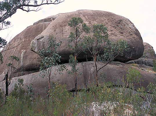
Across the road was the main trackhead, at a sign declaring that we had just arrived at the Border Track, a long trail connecting Green Mountains to a distant trailhead, Binna Burra. The Border Track is very well maintained for being the starting point of most day hikes in Green Mountains. We walked easily along the hard clay path before seeing a land mullet. Land mullets are a very large species of skink. This one was so big, I could have mistaken it for a baby crocodile if it had spikes on its back.

We continued to walk past intersection after intersection, always going straight ahead. The trees are gigantic in Lamington. Giant figs coated with vines and epiphytes loomed out of the green haze of the tree ferns. Vines were everywhere, and wherever there weren't vines there were cliffs. No small wonder explorers took so long to get this far. As the downhill slope on our left got steeper, I could sense a gigantic chasm to our left side, much deeper than it was wide. Both up and down, the slope went on and on without end. It was like we had shrunk to the size of insects, or like a small valley had grown to the scale of the Grand Canyon. Everything was much, much bigger than it should have been.

After an hour and a half of walking, we passed a gigantic Antarctic Beech -- so named for the place it was first identified, as a fossil -- and reached the beginning of the Albert River Circuit. We left the main trail on the right and followed an overgrown track, dodging fallen trees as the track narrowed. The Albert River flows on the next valley over from the Border Track, so I had expected to top out onto the ridge top between the two valleys. We never did. Instead, we contoured across the slope as it got steeper and and the path got surrounded by cliffs. For the whole time the track was doing this, I never suspected that we were slowly turning to the right, slowly winding around a mountain peak. Until the track switchbacked and it was obvious we were in a different valley than we started in.

The walking book we had (which was fairly outdated and may not have taken into account a track closure) told us we would reach the first waterfall of the track, Jimboomba Falls, about half an hour after turning off the Border Track. It was full hour and we had not even seen a creek yet. Then suddenly, we turned a corner and crossed a dry creek bed. Stupidly thinking this was Jimboomba Falls, we kept walking and then saw something totally weird. It was a lobster. Except it was crawling along dry ground far from a flowing creek. And it was blue and white. I don't know why -- I mean, it was just a lobster -- but it weirded me out. I learned later that this was a Lamington Spiny Crayfish, a freshwater yabby endemic to the Mcpherson Range between Tamborine and the Main Range.

Excited about the find of the crayfish, we walked easily to what was actually Jimboomba Falls to have a snack. The falls were just a small cascade, but they were interesting to see partly because thick moss growing on the sides made them look otherworldly. After checking for leeches we continued on a steep zigzag downward, sometimes clinging onto cliffs to avoid slipping and falling. Often we would have glimpses of the creek, which was always pouring over a high waterfall. At the end of the zigzag, we crossed the creek with glimpses of Lightning Falls -- a very high, free falling waterfall.

Earlier we had not been following the Albert River, but an offshoot called Lightning Creek. Just after Lightning Falls, we descended to the river itself. It was big, about five times as big as Lightning Creek. The first waterfall we discovered on the river was Mirror Falls. Mirror Falls was the most beautiful, mainly because of the mossy walls on either side of it. We passed four other, not very impressive falls in quick succession, before arriving at Echo Point Lookout which altered my view of the place completely.

Descending down to the creek was steep, but climbing back up was along more or less flat ground. Then we headed along a sidetrack to the lookout. Before I even arrived I could sense a void ahead of us, like we were standing at the edge of the Earth. In another minute we practically were. The Escarpment, which traces the New South Wales-QLD border, is a massive crescent shaped cliff that drops steeply and almost vertically about a kilometre into the plains below. We were standing on its edge, from which we could see the hulking ramparts of Mount Warning, the Border and Nightcap Ranges and even Byron Bay and the entire Gold Coast. It was the best view I have ever seen in SEQ, hands down.

We zombie walked for two hours back out along the Border Track, collapsing at what I hoped was a cafe'. It was the start of a treetop walk. Normally I don't like treetop walks -- I mean, they seem to be everywhere and I'm sick of them -- but this walk was pleasantly rickety and seemed like it would fall apart at any moment. I really liked it. We spent some time there, then walked back to the tents and collapsed.

If you are interested in walking the Albert River Circuit, or just want to know more, someone made an interesting video about it. A link is provided here.

The walks of the following day were done with another family who were friends of us. Since we had little time and energy left, we chose short walks around the area. The first one, to Python Rock, gave us a spectacular view over the mountains and really revealed how deep the gorges went. I would say they were about as big as Grose Gorge in the Blue Mountains, possibly bigger. Then we went on another walk, to the top of Morans Falls. But as we were arriving at the top of the waterfall, the sky broke apart and a torrential downpour began. Using any convenient track to get us back to safety, we ran up a muddy track labelled "O'Reilly's".

Suddenly, we emerged on an old gravel road. Not knowing where to go we just went right and found an old wooden shack. We raced to get under the eaves. Suddenly, Dad called to tell us the door was unlocked and we scrambled in. An information board revealed it to be an old slaughterhouse. My dad, I and my little brother were here, but no one else was, so we just sat inside and waited.

After twenty minutes the rain stopped. Noting that nobody had arrived yet, we just got out and walked along the track ourselves. Leaving the road to follow a promising looking track, we walked through a picturesque rainforest on a windy path that went through several large gum trees. Finally, we emerged at O'Reilly's where we met the others, sitting at a cafe'. They told us they had taken a different track, and had been waiting for us for half an hour.

Lamington is not the most amazing place in the world, or even Australia. But it is a great place and a must visit for anyone living in or visiting South East Queensland.

Thursday 15 December 2016

Girraween

In this article I am going to relate to my experiences in the Girraween area -- both on the most recent trip and on one I did, a year back, with Scouts.

The Girraween is by any measure an amazing place. While its largest granite outcrop -- Bald Rock -- is a fraction of the size of Uluru, the Girraween area gives you a sense of beauty that Uluru and the nearby Kata Tjuta lacks. Furthermore it is much closer to Australia's cities, being a mere three hours drive from Brisbane in Queensland's Granite Belt.

What does the place look like? The Girraween is located on top of a high plateau. A visitor to the valley below would never suspect it was there, if the signs were taken away. The top of the plateau is a large, undulating landscape, unremarkable except in one way: the rocks. They puncture through vast ribbons of eucalypt forest like needles, standing high above everything else but each other.

My first summit of such an outcrop was the climbing of South Bald Rock, a dome of granite that looks vaguely like a bald man's head. It happened on a Scout hike a year back. South Bald Rock is no moderate peak, approaching a height of 150 metres relative to surrounding plains. From the top we could see all the other peaks from a 360 degree view. To the immediate West lay the West and Centre bald rocks, then the rocky rise of Mount Norman that all but obscured Turtle and Castle Rocks, the Sphinx, and the Pyramids. To the East the view was more breathtaking: we could see Bald Rock, but behind it was a continuous ribbon of undisturbed forest that culminated in the gray spire of Mount Barney -- which was 90 kilometres away and should have been out of sight. Due to the curvature of the Earth, Mount Barney looked lower than us.

After that initial trip to the Girraween I vowed to return, and I finally did in October of this year. Not with Scouts this time, but in a family trip with friends. In Scouts, we completed the Eastern Peaks Circut: a lengthy hike involving climbs on the eastern (New South Wales border) side of Girraween National park. This time, we would visit the more built-up, western side of Plateau. Here was a visitor's centre and even a campground.

We were fairly ambitious on the first day, making a visit to the First Pyramid. The name of the Pyramid was inspired by its shape: a three or four cornered dome, tapering slightly at the top. To get to the summit we ascended a granite surface sloped at fifty degrees and smooth as glass. When we got to the top of this slope, we turned the corner and found the trail following a natural catwalk. Although the surface of rock was only tilted at thirty degrees or so, it tilted sharply toward a void I did not want to end up slipping into. My hands became shaky as I began the traverse, and I collapsed when I got to the other side.

The base is smaller than it seems.
We continued to the summit. The true summit was inaccessible as it was on top of a boulder, so we continued to a natural rock platform, from which we could see the climb route. Rather than sweeping 360 views we were promised by faraway views of the mountain, the view was dull and obscured by boulders. Still a good view, though. Then we scrambled to a viewpoint on the other side of the summit, which looked down upon another mountain: the Second Pyramid. It was weird, like a gigantic pudding dropped in the middle of the forest, and was completely devoid of trees or even subsidiary boulders. On the way back, we passed a boulder three times the size of a house yet balanced on a base the size of a dinner plate.

It was getting dark so we returned to the campsite.

The second day was much better. After some decision, we decided to walk to Turtle Rock.

Turtle Rock is a low dome of granite we saw from the Pyramid. It looks just like a sleeping turtle. Next to it is the Sphinx, a needle-like finger of rock poking out of a boulder field. The walk was supposed to take four hours, but we took five because we were exploring so much.

The walk began by climbing up through open eucalypt forest and scattered boulders. At long last, we got to the top of a ridge and followed it to the Sphinx. The Sphinx itself was not very impressive, but we spent an hour exploring the massive boulder field on all sides of it. A short walk brought us to the base of Turtle Rock. To get to the top, we scrambled up through a narrow gully. Then, just above a ledge with good views of The Sphinx, we were blocked from going further by a 5m cliff.
The turtle

The Sphinx and Turtle Rock from Castle Rock
I thought it was impossible to go further, but after some searching I found a slot crammed with boulders. If I scrambled along the boulders and chimney climbed through the slot, I could just make it. I did so. The going was hard though, and I almost got stuck twice. But I got to the top of Turtle Rock and was rewarded by 360 degree views.

On the return trip we climbed Castle Rock. It was much less exposed than The Pyramid and had much better views. After having climbed the mountain, we called it a day and retreated back into our tents.

Note: None of these pictures are ours.
Our final objective was Underground Creek. A short walk from the car park, Underground Creek was a creek that carved an overhang, which promptly buried the creek when it collapsed. Brave souls still venture into the cave below the overhang, to find the creek and more.

After thoroughly exploring Underground Creek, we set off for an offtrack adventure to find the fabled Aztec Temple (it's actually a jumble of boulders). We tried, and got as far as the ridge it sits on before turning back due to casualties.

The failed Aztec Temple expedition reminded us of how much we had not seen in the park. We will need to go back here sometime. As we drove home through the Main Range, I was reminded of how much there is to see in the world, and how we can only hope to see a fraction of it in our lifetimes.

The fabled Aztec Temple.

Saturday 27 August 2016

Neutron

There is a recipe in the back of Edward Lear's Book of Nonsense which begins like this:

"Procure some strips of beef,  and having cut them into the smallest possible slices, proceed to cut them still smaller, eight or perhaps nine times."

The recipe raises some interesting questions such as: What would these tiny pieces of beef look like? Is it even possible to slice anything past the molecular level? There is another question I am more interested in. If you slice things into small pieces, they take up less space. Could you eventually make things disappear entirely, just by slicing them?

As a matter of fact, it is fairly easy to break apart molecules; your body is doing it now. Atoms are more tricky, but scientists have split the atom more than seventy years ago. You rely on atoms fusing together in the Sun, after all. To answer our first question, the beef wouldn't look like beef past the molecular level. In fact, if you managed to split apart every single molecule in a slice of beef at once, it would trigger an explosion as the oxygen fuses to form the kind of air you breathe. (if you did the same thing to atoms, you would make a large nuclear explosion.)

Of course, it takes some pretty tremendous forces to split atoms. The only place where it is done on a big scale is in the core of a large star, when it dies. If a star is much bigger than our sun, it struggles constantly to stop collapsing in on itself.  The star relies on fusing atoms to survive. The moment a star runs out of fuel, its inner layers collapse. The outer layers of the star crash into the inner layers, and rebound into space in what is known as a supernova. What is left is the core. In a Sun-sized star, the core left is a white dwarf, which glows for a while before winking out. However, in a large supernova, the atoms are so strained by gravity they split apart and form an extremely dense and often quickly spinning object known as a neutron star.

Neutron stars are really strange things. They can be the size of cities but the mass of the Sun. They are mostly made of neutrons. Many have a fragile 'crust', which can fracture and create terrifying power surges. Some orbit a star, which they suck power from. Sometimes neutron stars merge and create massive bursts of light. Some neutron stars, known as pulsars, spin several times a second and emit energy from their magnetic poles.

Most weird aspects of neutron stars come from their incredibly small size and their amazingly large amount of mass. There is a type of object which has even more mass and a smaller size than a neutron star: a black hole. Black holes are made by splitting the components of atoms apart into individual quarks. Black holes are really weird. They are objects with a gravitational field so extreme, they can bend light. You cannot even see a black hole; you just see, well, a black hole. Around a black hole, time slows down and everything is redshifted. We barely know anything about black holes at all. All we know for sure is that they are unimaginably small and dense.

I wish there was a way to split quarks - the components of neutrons and protons - apart, but there isn't, as far as we know. And finally we arrive to the answer of our third question: It is not possible to cut a slice of beef into nothing, but you can make a black hole.

Friday 12 August 2016

Cultures

I noticed a lot of things in Switzerland that were not in Australia, America, or even northern Europe. One of them was the mountains. Australia's highest mountain is a mere hill compared to even the lowest mountain in Switzerland. Even the Rockies are no comparison to the mighty Swiss Alps.

However, the mountains were not what struck me most about the country. What struck me most was its culture.

The culture of an area is its identity. If someplace has a very old, established culture, it becomes instantly recognizable if you happen to be there. Australia was never properly populated before the Industrial Revolution, so its culture was mostly stolen from other continents; in Europe, however, country and even regional borders are obvious.

Let's take Italy and Switzerland - the two countries I visited this July. These two places, although neighbors, are shockingly different. One has been neutral for the past hundred and fifty years; the other has been heavily involved in both world wars. One has had a long history of organized crime; the other is one of the safest countries in the world. One makes great cheese; the other makes even better pizza. When I visited Italy on a day trip, the border between the two countries was obvious. It was marked on a pass by two massive stone eagles (a memorial of some battle victory in the Napoleonic Wars). To the north, there was a valley and beyond that, icy snowcapped mountains. In the valley there was a town with a visible church. The town seemed to have no center; it was stretched out across the valley floor. To the south, in Italy, the mountains tapered off abruptly and gave way to rolling hills, all sparsely covered with houses and lakes.

Cultures are interesting in the way that they carry on even when the geography that shapes them does not. For example, in Switzerland, there are two geographic regions: the Swiss Alps and the Rhineland. In the Swiss Alps, where Switzerland was first created, there is almost no flat land at all, except for that thin ribbon of farmland at the floor of each valley. As a result, all towns have only one road of any importance and the shops are spread out over hundreds of metres, sometimes kilometres. Curiously enough, when Switzerland grew to encompass the Rhineland, the system carried on. Look at a map of any city established under Swiss rule and you will see a distinct linear pattern.

My favorite thing about Swiss culture is the architecture. Architecture varies greatly all over the world. Even if a region has none of its own food, town layout or traditions, it will have its own architecture. Swiss houses and hotels have strange roofs for a place with a lot of snow; they have almost vertical outer sides and very flat tops, like boxes. Not all of them do of course; it's different in every single valley, just like the food and many other things are. And that's what I like most about Swiss culture: its variation.


Tuesday 19 July 2016

Invisible light

We perceive the world in the three colors that our eyes can sense- red, green and blue. This gives us a visible range of all of the wavelengths in between 390 and 750 nanometers. However, there are wavelengths in the infrared and the ultraviolet that, if viewed by a special camera, can reveal much more about the world than our eyes can. I am working on a project to build a new type of these cameras. In the following paragraphs, I will explain more about how they work and about the one I built.

Cameras that can see past red and past violet are called multispectral cameras. These cameras can be mounted on satellites to view natural features and cities in a way that no ordinary camera can. There are many different regions of the spectrum, most of which can only be seen with the aid of such a camera. The ultraviolet is mainly used to photograph biological compounds, while the near-infrared has a wide range of applications. The near-infrared is a band of wavelengths that is just beyond red. It ranges from 750 to up to 1400 nanometers. Even though this is beyond visible, these wavelengths are still extremely small- up to 1.4 times a thousandth of a millimeter.

The way to reveal the most about an object using multispectral imaging in the near-infrared part of the spectrum is to filter out one wavelength at a time. However, technology that can do this is very expensive. This is why I am working to make a cheaper multispectral camera.

Instead of filtering incoming light into different wavelengths, this camera works by having both the camera and the object inside a box to block out all other light, and illuminating the object with LEDs that emit light in various wavelengths in the visible and near-infrared parts of the spectrum. Both the LEDs and the camera controlled by a type of small computer called a Raspberry Pi. The computer is programmed to flash each color of LED in succession while taking pictures with the camera. This way, the images can show how an object reflects and absorbs different wavelengths of light individually. This method is cheaper, and its only limitations are the spectral range of the camera and the variance of the LED colors.

For the programming of the camera, I used a programming language called Python, with which I was able to write the programs for the operation of the camera over an internet connection with the Raspberry Pi. One of the problems I faced was how to make a Printed Circuit Board(PCB) that included places for all of the LEDs so that I could solder them. I did this with a program called gschem.

The type of multispectral camera described above can potentially have many uses in agriculture. It would be able to detect bruises on fruit and possibly detect when it goes rotten much faster than human eyes can. It could also detect diseases in plants. In conclusion, multispectral cameras can be very useful to help us understand the world we live in more fully.

References:
https://en.wikipedia.org/wiki/Multispectral_image
https://en.wikipedia.org/wiki/Near-infrared_spectroscopy

Monday 30 May 2016

Grain of Sand

It is no wonder that geologists swarm to the Jack Hills, Western Australia -- for it is the site of the oldest rocks on Earth.

There are larger old rocks in Canada, but they are 500,000,000 years younger than the Jack Hills rocks. There are older meteorites in Antarctica, but they were not formed on Earth. The rocks at the base of the Grand Canyon -- thought by many to be the oldest rocks on Earth -- are a whopping 2,650 million years younger than the rocks of Jack Hills.

Being about 4.4 billion years old, some rare Jack Hills sand grains came from the first rocks Earth ever had. However, the old rocks of the Hills are just that: a few very rare sand grains, called zircons, which are deeply embedded in sedimentary (made of sand) and very metamorphic ('changed') rocks. How did these tiny grains appear here in the first place, and how might they have survived the wear of time? Why are they so rare in the first place? Let's go back in time to find the answer.

The Crust Solidifies

4.4 billion-years-old Earth is not a place you would want to live. A human, dropped on the prehistoric planet's surface, would be fried by nuclear radiation, burned by lava, choked to death by poisonous gases, and crushed by meteorites within the first five minutes. One good thing about early Earth: Oceans. Scientists have found out that the Jack Hills zircons were created in water; water which could have come either from meteorites or the planet itself. In any case, Earth had oceans, but still wasn't cooled enough for the igneous rocks to turn into anything else, whether sediment or metamorphic rock. Also, there was virtually no oxygen. This meant, for now, that the early rocks were safe from change. That is, until . . .

Life Begins

Life is currently thought to have originated around 4.0 or 3.9 billion years ago. The oldest evidence for life comes, like the earliest evidence for water, from those same Jack Hills sand grains. Life did not have much effect on early rocks until about 3.4 billion years ago, when the Earth had cooled down significantly and erosion had begun creating the first sedimentary rocks. Around this time, moss-like cyanobacteria began making the first stromatolites (crazily, the only colony of stromatolites left is within sight of the oldest rocks). Cyanobacteria use photosynthesis, a complicated process which turns carbon dioxide, water, and sunlight into sugar and oxygen. The latter was released on a massive scale into the atmosphere. This would not have been that bad, but there was a lot of iron in the volcanic rocks. The oxygen and iron combined to form rust, and immediately the age-old rocks from Earth's creation began to fall apart. Jack Hills zircons, not being made of iron, had survived for the time being. However, an important factor was now coming into play . . . .

Radiation

There were trillions of trillions of zircons on Earth when it was first created. Corrosion and heat did not change their numbers very much. However, around three billion years ago, the zircon crystals began to break apart, due to a process known as metamictization.

Early Earth was very, very radioactive. Rare elements today, like actinium, used to be very common four billion years ago. Uranium-238, the most common radioactive element, has a half-life of about 4.5 billion years. This means that a 200-atom sample of uranium from the creation of Earth would have about 100 atoms now (the other atoms would have turned into something like radium). A by-product of radioactivity is radiation, in this case in the form of alpha particles. You may expect a zircon to have had about a million atoms of uranium in it 4.4 billion years ago. By now, the decaying uranium would have released at least 500,000 alpha particles -- more because what uranium decays into, decays into something else. 500,000 alpha particles are more than enough to destroy the crystal.

A few, very rare zircons would have survived long enough to endure the next test.

Plate Tectonics

In 2013, scientists were shocked to recognize the remains of a massive continental plate, lodged deep within the Earth underneath North America. This plate was called the 'Farallon Plate', and was later discovered to have been shoved underneath the crust by the Pacific and North American plates.

As shocking as it may be, it is not uncommon for a continental plate to slide underneath the crust, never to come back again. It has happened throughout the history of the Earth since plate tectonics began, around 4 billion years ago. Every 300 million years or so, the Earth's crust is recycled. Our zircons could hold out under the immense pressures of the Mantle for a while. Eventually, however, even the strongest crystal on Earth could not survive.

What saved our zircons is exactly what destroyed all the old rocks: Erosion.

The zircons, swept by the wind, would have spread across the world, minimizing the chance of all being destroyed. They would become part of normal sandstone rocks, which would erode and the zircons would have been released again. Nevertheless, the oldest zircons became rarer and rarer. Finally, around 600 million years ago, a group of zircons became embedded in some sandstone rocks. Eventually, as most of their neighbors were slowly destroyed, the last zircons got buried under heaps of volcanic rock. The surrounding land went through cycles of burial and erosion, but the zircons were protected by the volcanic rock. After being warped by pressure, the sandstone containing the zircons slowly, but surely, was uncovered. It was now part of the western Australian plate.

Monday 18 April 2016

The Adventures of Gold


The Adventures of Gold


Gold was inside his shop, making magic wands like he always did on sunday afternoons.
However, it was not a Sunday afternoon. It was Friday morning. Normally, he would be in some important government meeting, but not today. Today he got the day off. But why did Gold make wands to sell at his shop during free time? Surely not money! He was the richest and most famous dragon in Great Britain! He did it purely for fun. Suddenly the doorbell rang.

“Come in!” yelled Gold. The door creaked open. Suddenly, a young cat burst through the
doorway so fast, he broke one of Gold’s Ming vases into a million pieces.

“Gold! You’ve got to hear this!” he said.

“But my Ming vase!” Said Gold.

“Come on!” Said the cat. “Your Ming vases come from Squeaky-E-Mart and cost ten cents! This is more important!”

“But…” said Gold.

“Listen to me!” said the cat. “The candy factory shut down!”

Gold froze in place. Even though he was middle aged, his longing for candy was stronger
than ever.

“Why did the owners shut it down?” said Gold.

“They didn’t.” said the cat. “The Vipers did”

“Who are the vipers?” said Gold.

“The vipers?” said the cat. “The Vipers are a famous gang of bulldogs. They have done worse and worse things over the past few years. yesterday they blew up a bridge.”

“But how do you know that the Vipers shut down the factory?” said Gold.

“I got a ransom note.” said the cat.

“May the King help us!” said Gold.

“I am the King.” said the cat.

“Oh. Right. Sorry.” said Gold. “Your hair style mislead me.”


“So how do we get them?” said the King.

“A crystal ball!” said Gold. He pulled an apple sized ball out of a cupboard.

“How does it work?” said the King.

“You say something into it and it takes you there!” said Gold.

“What makes it cloud up like that?” said the King.

“Cloudy apple juice.” said Gold. “The crystal ball only has one charge, so we have to use it wisely.”

“Go ahead.” said the King.

“Take us to the Vipers!” said Gold. Suddenly, in a whirlwind of colors, they got transported 
to a dingy old room with four bulldogs huddled around a table.

“Hands up!” said Gold. A bulldog spun around.

“What do you want?” said the Bulldog.

“Fix the candy factory!” said gold.

“We never shut it down.” said the Bulldog. “The ransom note was a lie!”


The next day, Gold was helping the King put the Vipers in jail, as well as whining his head off.

“I wasted a crystal ball, a train ticket a boat ticket, lots of time, and most importantly my 
ming vase, only to find that nothing happend at all!” said Gold.

“Not really.” said the King.

“What do you mean, ‘not really’?” said Gold. The King pulled a trophy out of his bag.

“As your King, I give you this award for helping me capture the most troublesome gang in Great Britain.” said the King.
                                                        The End!


Sunday 17 April 2016

Hydrogen

 Hydrogen is the simplest and most abundant element on the periodic table. It consists of one proton and one electron. Its atomic number is 1 and its chemical symbol is H. Through this post I will write about its importance in the past, its fourth state of matter, and the inner beauty that it exhibits light-years away.
The Hindenburg disaster

Hydrogen was named after the two Greek words υδρο(hydro), meaning water, and γενης(genes), meaning creator, when it was discovered to create water when burned. In its pure state, hydrogen is a gas that is invisible and highly flammable. Because of its low density, hydrogen  is one of the two atomic elements that is lighter than air. this makes it able to float large objects. People took advantage of this fact by building blimps(zeppelins), aircraft that use the lifting power of hydrogen. They carried more than 35,000  passengers over the years from 1910 to 1914 without serious accident, but on 6 May 1937, the passenger airship Hindenburg mysteriously caught fire and crashed in New Jersey. From then on, hydrogen was considered far too flammable as a lifting gas.

As a gas, hydrogen is colourless, odourless and tasteless, yet we benefit from it every day. It is visible as a plasma in all stars, including our sun. The sun is mostly hydrogen that has been exposed to high temperatures or a strong electromagnetic field, converting it into plasma, the fourth state of matter. As a plasma, the hydrogen atoms are stripped of their electrons. This makes it possible to fuse hydrogen atoms together into helium, and to produce the intense amount of heat and light that is crucial for the Earth's ecosystem.

Hydrogen, like all other elements, has a dark side. The sun constantly emits positively and negatively charged hydrogen ions through interplanetary space. This is called solar wind. These particles can travel at up to one million miles per hour. Fortunately for us, Earth is protected by a magnetic field, which shields the planet from solar radiation. Were it not for this magnetic field, much of the Earth's atmosphere would have been stripped away by solar wind, rendering it lifeless.
The Ring nebula

Hydrogen was first created by the big bang, roughly 13.7 billion years ago. Ninety percent of the universe consists of Hydrogen, which is mostly in stars and nebulae. Nebulae are mostly ionised hydrogen which glows in hydrogen's spectral emission lines. When I lived in a place with less light pollution, me and my family went outside with a telescope to look at the stars. One object that is visible in the Australian night sky is the Orion nebula, which appears as the middle 'star' in Orion's sword. My favourite nebula is the Ring nebula, which lies in the constellation Lyra.

Friday 25 March 2016

Base systems


A base system is a system in which we count. Most people are familiar with the normal base-10 system, also called the decimal system. Each base system has its own unique set of numbers, like the decimal system, which has exactly ten.

The good thing about using a base system is that there does not have to be a different symbol for each number, which would be very confusing and hard to keep track of. Instead, the numbers count up through all of the symbols in the whole system, and then the system adds an extra digit and starts over again.

Computers have to bring this to the minimum, because an electrical current is either off or on. It is hard to get more information with simple digital devices, such as transistors, and it is hard to vary the current in any other easily detectable way. This results in only two "symbols" that a computer can use, so in counting, computers use the base-2 system, or the binary system.

Binary
The two 'symbols' in the binary system are usually represented by 0 and 1, and they are referred to as bits. These can combine to make long sequences that are used in computers. For example, whenever you press a letter on a standard keyboard, an eight-bit sequence of ones and zeroes gets sent to your computer.

Even though binary is simple, it also gets very long. All of the numbers from 0 to 10 in the decimal system can be represented as 0, 1, 10, 11, 100, 101, 110, 111, 1000, 1001 and 1010 in binary. All of the even numbers end with a zero, and there is a twos place, a fours place, an eighths place, a sixteenths place and so on. A computer byte, or eight digits of binary, can range through all of the numbers from 0 to 255. 109 in the decimal system is the same as 1101101 in binary.

Octal
The next counting system I want to focus on in this post is octal. This is the base-8 numeral system. Octal has been used by some of the native Americans for counting, because they counted on the spaces in between their fingers, and not the fingers themselves. Over history, octal has been proposed for many things such as coinage and counting, but in the present day, it is not widely used.

Octal uses only the digits 0-7. One helpful thing about the system, is that eight is the cube of two, or 2x2x2. This makes multiplication and division easier. The number 109 is represented by 155 in octal.

Decimal
The next system is also the most commonly used; the base-10 system, or the decimal system. We use the system only because we have ten fingers, so we have the decimal system solely due to evolution. If we had evolved with four fingers on each hand, we would be using octal!

The decimal system is very old. It was used by the ancient civilisations of Greece, Rome, Egypt and China. The oldest decimal multiplication table was made out of bamboo slips and came from the Warring States period in China. Romans had an interesting way to make decimal numbers, only needing numerals for 1(I), 5(V), 10(X), 50(L), 100(C), 500(D) and 1000(M). The Ancient Greeks did not use numerals, and instead used the letters Alpha-Theta as the numbers 1-9, Iota-Koppa as 10-90, and Rho-Sampi as 100-900. The number 148, for example, is translated as ρμη(RUE) in Greek(Notice that the Greek counting system includes the three letters Digamma, Koppa and Sampi, which are now obsolete in language). 109 in decimal is the same as the number 109. This example is not needed.

Duodecimal
One numeral system that is commonly used in America is the base-12 system, also called the duodecimal system or sometimes dozenal. This system is used today in foot-inch and single-dozen-gross-great gross systems as well as most clocks. You might sometimes refer to the number six as 'half a dozen', or twenty-four as 'two dozen'. In the duodecimal system, 24 translates to 20. The duodecimal system can be helpful because it is divisible by 2, 3, 4 and 6.

You may notice that in all of the systems I listed before, only numbers from the 0-9 set are used, however duodecimal has to count through all of the numbers 0-11 without adding another numeral place. This means that the system needs extra symbols to represent 10 and 11. These can be an inverted 2 for 10 and an inverted 3 for 11. The number that is 139 in the decimal system is the same as 37 in the duodecimal system.

Hexadecimal
The next numeral system is based on 2 raised to the fourth power: the hexadecimal system, or the base-16 system. This system requires sixteen different symbols, so the letters A-F are used for the numbers 10-15.

The hexadecimal system is highly involved in computer screens. Each pixel on the screen of a computer is made of three different lights, coloured red, green and blue. The brightness of each of these lights can be adjusted from 0(off) to 255(maximum brightness). This can vary the colours of each pixel. For example, red=255, green=128, blue=0 can colour a pixel bright orange. Each number in between 0 and 255 can be expressed as an eight-digit number in binary, or a two-digit number in hexadecimal. Six-digit series composed of hexadecimal numbers are used in HTML and other programs, two digits to represent each colour. In this form, bright orange would be #FF8000. 139 translated into hexadecimal would be 8B.

Vigesimal
The vigesimal system is the base-20 numeral system. It consists of the numbers 0-9 and the letters A-J. The letter J represents 19. It is used in the Mayan and Aztec language with its own symbols. This system is not all too different from the decimal system, because it is based on two times ten. 139 is 6J in vigesimal.

Sexagesimal
Sexagesimal is the last numeral system in this post. The extremely helpful thing about sexagesimal is that its base, the number 60, can be divided by 12 different factors including 1, 2, 3, 4, 5, 6, 10, 12, 15, 20, 30, and 60. It was used by the Babylonians, but I would not say that their counting system was completely base-60, because the Babylonians used decimal as a sub-base.

Of course, sexagesimal is still used today, in geographic coordinates(degrees, minutes and seconds), and time(hours, minutes and seconds). On clocks, the system fits together well with the duodecimal system, because exactly five minutes fits in between each hour. It is no wonder that this system, which was used by the Babylonians, is still used today!


Resources: Wikipedia, "List of numeral systems"
 

Monday 22 February 2016

Movie of the year

If you are friends or family to the Gensemer family, you might have received our Dear Friends letter in early January. This letter includes events and experiences during the last year, described in accounts by each family member. Each family member also picked a book and movie of the year. This post is my review of each movie. I am also including the director of each movie and its rating on the Rotten Tomatoes website.


Arwin's(11 years) choice:

Field of dreams(1989), directed by Phil Alden Robinson.

This movie is about a corn farmer in Iowa, who gets notified by a strange voice that, "If you build it, he will come". The farmer later finds out that if he builds his own baseball field, the ghost of Shoeless Joe Jackson(who was banned from professional baseball in 1920 after the Black Sox scandal) will come and play baseball again. This movie also includes other famous baseball players.

Even though the movie is themed on baseball, it is also about magic and family togetherness, and has a good, warm feeling to it.

Rating: PG, due to "a bit of strong language".
Rotten Tomatoes ratings:
Tomatometer(critic ratings): 86%
Audience rating: 86%


Daniel's(13 years) choice:

Interstellar(2014), directed by Christopher Nolan.

Wikipedia calls this "[An] epic science fiction film". It is set far in the future, when humans are at threat from natural disasters that are wiping out crops. The main character is Cooper, a former NASA pilot who runs a farm with his daughter, Murphy, and other relatives. Murphy believes that there is a "ghost" haunting her bedroom and pulling books out of the shelves. During a dust storm, Murphy's "ghost" forms lines and bumps in the dust. Cooper later finds out that the lines are caused by gravity and that they are a binary code for a set of geographic co-ordinates.

Some critics rate Interstellar three out of five stars because some of the dialogue is hard to comprehend, but I like it because it is exciting and includes many scientific theories about black holes, wormholes, space and time. It is probably the best science fiction movie I have ever watched.

Rating: PG-13, due to swearing.
Rotten Tomatoes ratings:
Tomatometer: 71%
Audience: 85%


Wytse's(13 years) choice:

Song of the Sea(2014), directed by Tomm Moore.

This is a hand-animated movie about Irish myth. It also includes Irish settings and music. The story starts at a small island off the coast of Ireland, which is the home of a lighthouse keeper named Conor. He lives with his son Ben and his wife, who mysteriously disappears and leaves him with Saorise, their newborn daughter. Six years later, Saorise can still not talk and she is constantly being teased by her brother Ben. She is then found washed up on the beach, by their visiting grandmother. Granny declares that living on the island is too dangerous for them and starts taking them to the city.

The thing I like most about this movie is not the plot, but the animation. The animation makes it a very colourful and flowing artwork. It also has interesting references to Irish mythology such as Mac Lir the giant, Selkies, and Faeries. I think it is a good family movie.

Rating: PG
Rotten Tomatoes ratings:
Tomatometer: 99%
Audience: 92%


Nynke's choice:

Never Cry Wolf(1983), directed by Caroll Ballard.

This is a true story, based on the autobiography of Farley Mowat. It starts when a biologist gets sent into the wilderness of Canada on a government project to discover why caribou populations have been decreasing. He also needs to find out if wolves have anything to do with the problem, even though no one has witnessed a wolf killing a caribou.

One thing I have to tell you about is that this story has a sad ending, however, it features many amazing natural landscapes, and information that the biologist finds out about the wolves. It also depicts wolves as social, friendly, and helpful as a part of nature, unlike savage and menacing, which is the common view of wolves.


Rating: PG, due to "a few gross scenes".
Rotten Tomatoes ratings:
Tomatometer: 100%
Audience: 85%


Stephen's choice:

Selma(2015), directed by Ava DuVernay.

This movie is also a true story, a story about American history. It is about the Selma to Montgomery marches, a series of protest marches led by Martin Luther King, Jr., who is well known for having led many protests against racism and poverty. The Selma to Montgomery marches were part of the Voting Rights Act, an act that allowed black people to vote. They went along the 54-mile stretch of highway in between a small town in Alabama and the state's capital. The movie was based on F.B.I. accounts of these marches.

Rating: PG-13, due to violence.
Rotten Tomatoes ratings:
Tomatometer: 99%
Audience: 86%

Tuesday 2 February 2016

The Tweed Volcano

You may not be surprised to know we've been busy in the holidays this summer (or, for our Northern Hemisphere friends, the winter). To start off, some friends visited over Christmas. Then we went off on a small trip to the Nightcap Range.

The Nightcap mountains are well known as being the home of the hippie town of Nimbin. Nimbin, closely linked to the coastal town of Byron Bay, is a big tourist attraction and a diversion from the colorless Pacific highway. We never visited it on the trip, but drove up a steep dirt road to a campsite within the range itself.

Nightcap Range is shaped like a C and is much wider than it is long. It gradually gains altitude from the Nimbin valley north, transitioning from hilly farmland to cliff-riddled rainforest. At around 800m of altitude, it slopes off in a dramatic and crazily steep escarpment to a coastal valley. Nightcap is just one ridge of many that make up one massive and perfect circle of mountains and cliffs known as the Tweed Volcano. Standing high in the centre of the crater, alone, is the imposing spire of gray rock known as Wollumbin.

Wollumbin, or Mount Warning as it was named by Captain Cook, is 1150 metres high (that is, from the summit to the valley floor, it measures over a kilometre). It is a remnant of the Tweed shield volcano, which used to be (and still is) so wide it could cover the state of Vermont. We only stayed on the eroded southern slope.

On the first day, we took the longest walk available in the area.

The walk began at the campsite, which appeared to be infested by goannas (or just one that seemed to be devoted to stalking me constantly). At arrival, I noticed signs of logging around the campsite, such as a stand of hoop pines lined up in rows, and a disused logger's cabin that was falling apart. I learned from information boards that logging had stopped here in the 1980s.

After having breakfast, we began walking down the creek. The path here wove through dense rainforest. Whenever the creek came in sight, it looked like a stagnant puddle. Soon the forest opened up, and the path clung to the creekside as it tumbled over rocks and wove through scrubby eucalypt forest. After forty minutes, the path ended at a lookout platform perched on the top of Minyon Falls.

Minyon Falls was where the creek we were following plunged into a broad gorge surrounded by tall, sheer cliffs. About four kilometres down the gorge, the walls opened up and the gorge joined a valley. We had to hike over there and back in order to reach the base of the falls. The first leg of the hike involved walking out and ascending to a point, with unfenced cliffs on both sides. The second leg was much more beautiful. We walked through beautiful rainforest dominated by massive strangler figs and swaying palm trees. Then we crossed a rocky creek, and ascended a debris field to the waterfall's plunge pool.

The waterfall was so high, it disappeared before reaching the bottom. I noticed outcrops of hexagonal rocks on the cliffs and down below. I had seen these peculiar rocks in other places, too.

The walk back up to the lookout, which travelled up the other side of the gorge, was much quicker and steeper. We reached the campsite in time for dinner.

Wollumbin is popular for being the first point in Australia, and every other mainland country except for Russia, to see the light of day. Wollumbin (Mount Warning) is one serious mountain, and is proof height does not equal hardness (so is Kosciuszko, but in a different way). The track to the summit is steep, zigzagging, and endless. Near the top is a seventy degree rock wall with a chain.

On the morning of the second day, we got up and hiked to the top.

The drive into the crater was pretty long, since we had to drive around the steep crater escarpment first, to a gap in the cliffs. From the gap we drove through some beautiful but very hilly farmland, and at long length reached the road that zigzagged up through Wollumbin's lesser satellites to a "carpark". The carpark itself, which we had the privilege to park in, was only about eight spaces and cars clung to the side of the road up to a kilometre away from the trailhead itself! (and we were there in the shoulder season).

Anyway, the walk began as a paved concrete path with no steps. As we climbed up through some beautiful woody rainforest, the path became brick. Then the path contoured upward. The path, which was dominated by steps this time, became a well-drained dirt path with wooden steps and information boards.

I had never before been on a pathway that was wheelchair accessible for the first 200 metres, and a near vertical climb in the last 200 metres, but that was what the path was like. Once we left the open rainforest and began climbing through what was basically a massive tangle of vines, the wide path degraded into a very rocky and muddy dirt trail with no steps. It stayed this way almost to the top. About 1200 metres up the track, we reached a massive clearing (with a view!) in the middle of which stood a helicopter platform. There were no less than four of these on the way to the top.

Half an hour later, when we reached Helicopter Landing Point 2, absolutely nothing had changed. We were still zigzagging steeply through a damp and muddy vine rainforest. We were 2.2 kilometres from the carpark this time. The views had gotten better, but they still weren't very impressive. Then, not far from the platform we reached a sign that announced our arrival at the halfway point. From there, the forest changed.

Earlier, we had been seeing coachwood trees and other rainforest plants. Now we began seeing eucalypts, and the forest just began to dry out. The track stopped zigzagging, and began to head consistently to the right. Soon the trail became a hard dirt trail, reinforced by rocks. In what seemed like no time, we reached helicopter point 3, which was 3.2 kilometres from the carpark and just 1.2 kilometres from the summit.

This place was the first real view. I could see out to the sea, but I could also see what was directly above us; a cliff of massive proportions. I had no idea how the path could get to the top of this.

Although the trail kept on zigzagging up, it never really reached the cliff. Maybe we were slowly circling the mountain the whole time.  Anyway, helicopter point 4 was in a large grove of spear lilies, found nowhere on Earth but a small collection of high mountains around the NSW-QLD borders. It was a scarce 300 metres from the top, and a mind blowing 4 kilometres' walking from the trailhead.

For about five minutes, we walked through an ancient mountain forest filled with mossy Antarctic beech. The forest ended finally when the track stopped dead by a picnic table, at the base of the cliff I had seen earlier. The track seemed to go straight up this cliff. The climbing had begun.

At close inspection, the cliff had plenty of holds and I could almost walk up it. Soon enough, we arrived at the summit. There was no one view, but five separate view platforms ringed the summit. I could easily see the whole crater. It was great summiting.

The trip back down the mountain was uneventful. I went to sleep happy.

On the third day, we ventured to the coast and Byron Bay. I visited the lighthouse viewpoint, and walked to the easternmost point in Australia. We stopped at a lookout in Ballina, a nearby town.